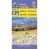


Zakros Vai Hiking Map 1: 25,000
8,50 €
Description
Zakros Vai Hiking Map 1: 25,000
Hiking map from the area of Zakros on a scale of 1:25,000
The new version of the Zakros Vai map, now called Zakros Vai Sitia, covers the entire eastern end of Crete, from Sitia, Kavo Sideros and Zakros to Xerokambos and Goudouras in the south. An area unknown to most of the world that has unique geological and natural wealth: caves, canyons, rare rocks and fossils and has been proposed for a geopark. The geopark operator has created a series of marked walking and cycling routes which are mapped and mapped. In the area of Kato Zakros, one of the great Minoan Palaces of Crete has been excavated, which was a center of trade and transactions with the countries of the East.
The map is printed on waterproof and durable Polyart paper.
Additional information
| Publications | Anavasi |
|---|---|
| Year of publishing | 2019 |