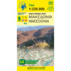


Central Greece Epirus Thessaly Road Map 1: 230 000
8,50 €
Description
Central Greece Epirus Thessaly Road Map 1: 230 000
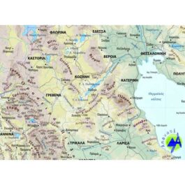
Road map of Central Greece, Epirus and Thessaly at a scale of 1:230 000
New version of the Central Greece - Thessaly - Epirus map. A very useful map of the series of Regional maps, covering half of mainland Greece, from Konitsa to Katerini in the north and from Messolonghi to Thebes in the south. It includes all the new highways (Egnatia road, Ionia road, central Greece highway, PATHE), and their sections under construction geophysical relief with names of mountains, lakes and rivers, settlements, monasteries, monuments, national parks, the European (E4, E6 ) and national trails (O1,O2,O3), mountain refuges, ski resorts and much more.
Along with the map, 10 suggestions for excursions to the most beautiful nature destinations in the area covered by the map.
Additional information
| Publications | Anavasi |
|---|---|
| Year of publishing | 2018 |