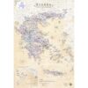


Parnitha Hiking Map 1: 25,000
8,50 €
Description
Parnitha Hiking Map 1: 25,000
New and updated 2021 hiking map for Parnitha at a scale of 1:25 000.
On the back of the map there are two enlarged maps on a scale of 1:10 000, for the area of Flampouri and the Tribe.
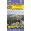
Parnitha is the ideal destination near Athens for a day trip or a short crossing. And who hasn't walked from the Cable Car (or the Casino) to the Buffy Sanctuary? Hasn't he been down Hunis at least once? One of the favorite routes is the Flambouri ridge because it is so wild and steep that one tends to forget how close it is to the city!
Parnitha is the natural refuge of the Athenians' contact with nature. Fir forests, ravines and vast scrub, deer and birds are manifestations of the wild nature we seek. It is an ideal destination for hiking, climbing, mountain biking, or even to build a snowman with the first snow.
This map of the Ascent, after several reprints, captures with remarkable detail and accuracy the many routes of the mountain as well as all the information that is useful to the hiker. This work is not only the product of our own work and efforts, but also of the numerous hiking friends who share their records or observations with us, as a result of which the map becomes better and better.
The map is printed on the innovative Polyart synthetic paper with a removable cardboard cover.
Additional information
| Publications | Anavasi |
|---|---|
| Year of publishing | 2021 |