


Psiloritis Hiking Map 1: 30,000
8,50 €
Description
Psiloritis Hiking Map 1: 30,000
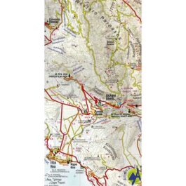
Hiking map of Mount Psiloritis (Mount Idi) at a scale of 1:30,000
Imposing, precipitous and rugged, the breeding ground of Zeus, wild goats and the untamed Cretan soul, Psiloritis dominates the center of the island and the hearts of the Cretans. There are paths and climbs from all sides to its highest peak, which also has a stone chapel of the Holy Cross, something we often find on the peaks of Crete.
The map shows some new hiking routes such as the Cretan Way and the new shelter at Lakka Mygerou, starting point for the most popular ascent to the top. The mountain is also of great archaeological interest, hosting the two famous caves, the Idaion cave and the cave of Kamaras, as well as the archaeological site of Zominthos - a Minoan palace that has not yet revealed all its secrets. On the reverse side of the map, suggested hiking routes, small texts and pictures. The map is printed on waterproof and durable Polyart paper.
Additional information
| Publications | Anavasi |
|---|---|
| Year of publishing | 2018 |