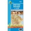


Tzia / Kea Hiking Map 1: 27,000
5,50 €
Description
Tzia / Kea Hiking Map 1: 27,000
Hiking map of Kea (Tzia) at a scale of 1: 27,000
An island with mountainous terrain, rich vegetation, abundant spring waters and beautiful cobbled paths, Tzia is ideal for hiking. Especially since most routes are well signposted and lead to wonderful secluded beaches.
The visitor who wants to get to know the countryside of Kea is offered 12 routes where most of the natural and historical wealth of the island is gathered. It is a network of routes of about 80 kilometers, most of which are paved paths. Their marking with the characteristic red / white plates is partially complete. The creation of the network is an application of the program "Routes of Cultural Interest in the Cyclades" implemented by the Department of Culture of the South Aegean Region. The routes combine natural landscapes and invisible inland monuments with descents on the most beautiful beaches.
Kea is a paradise for walkers as it has a network of trails, with a total length of 81 km, with several of them being paved. The paths were part of the ancient road network that in the 7th-6th century connected the city-states with each other. On all paths there are wooden signs with information about the route and small metal signs with the number of the path.
The map is printed on waterproof Polyart paper.
Additional information
| Publications | Anavasi |
|---|---|
| Year of publishing | 2019 |