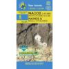


Amorgos Hiking Map 1: 32,000
7,50 €
Description
Amorgos Hiking Map 1: 32,000
Hiking map of Amorgos on a scale of 1:32 000 trilingual version Greek, English and French.
New version of the hiking map of Amorgos at a scale of 1:32 000.
From above, Amorgos looks like a skeletal form whose sides emphasize the gorges, but as one approaches, the constant changes in the landscape become clearer and take on meaning: the archaeological sites of the first European societies, the Hellenistic towers, the monastery on the cliff , the terraced crops, the white houses and small churches that bless this unexpected fertility. Also, the riverbeds that keep the water cool, countless wells, ancient tanks and cool water springs belie the initial impression. Each of these points tells the story of the millennial coexistence of man in the Cycladic landscape, a story of hard work, but also of elevation towards a refined spirituality.
And the narration of this story unfolds step by step and is revealed to the hiker who follows the ancient paths of the island.
Printed on Polyart plastic paper, waterproof and durable to use.
Additional information
| Publications | Anavasi |
|---|---|
| Year of publishing | 2021 |