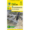


Cyclades Argosaronikos Road Map 1: 200 000
8,50 €
“Κάστρο Εδιμβούργου, Χάιλαντς, Λοχ Νες και όλα τα σπουδαία αξιοθέατα της χώρας. Όλες οι πληροφορίες που χρειάζεστε για να οργανώσετε το τέλειο ταξίδι! Περιλαμβάνει και λεπτομερείς χάρτες και πλούσιο φωτογραφικό υλικό.
Description
Cyclades Argosaronikos Road Map 1: 200 000
Travel map of the Cyclades and the Argosaronic at a scale of 1:200 000
The travel map Cyclades - Argosaronicos is an Ascent title covering the regions of Attica with the islands of Argosaronicos, Salamina, Aegina, Hydra and Poros and all the islands of the Cyclades, printed on both sides with overlay.
A very useful map for travelers, highlighting the spatial relationships between the islands. On each island you will find a short text with the main monuments, the most beautiful beaches and the path networks. Indispensable supplement to each of the individual detailed walking maps of the islands issued by our publications.
Printed on waterproof Polyart paper.
Additional information
| Publications | Anavasi |
|---|---|
| Year of publishing | 2017 |